| | Heightamp preview thread |  |
|
|
|
| Author | Message |
|---|
Jaachym
Lead Researcher

Posts : 68
Join date : 2010-02-10
| | Subject: Heightamp preview thread Sun Mar 07, 2010 4:07 am | |
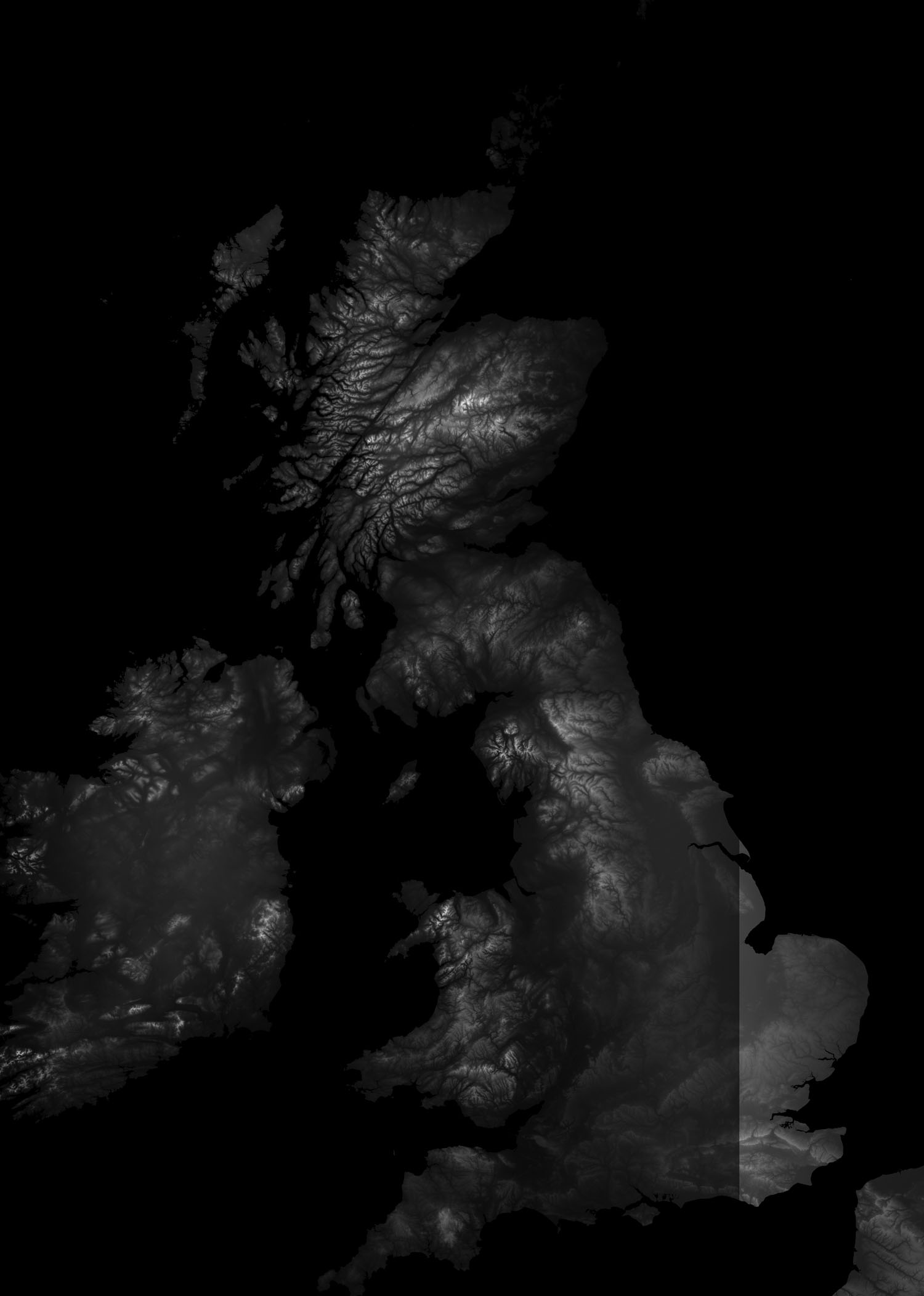
| This thread is ment to be just preview thread so please do not post a comment if not necessaryFirst heightmap preview: after 2 days of work (mostly trying to figure out how to do it) this is height map which I have extracted from google earth (only preview actual height map have 1.01GB) It is pretty detailed - Spoiler:
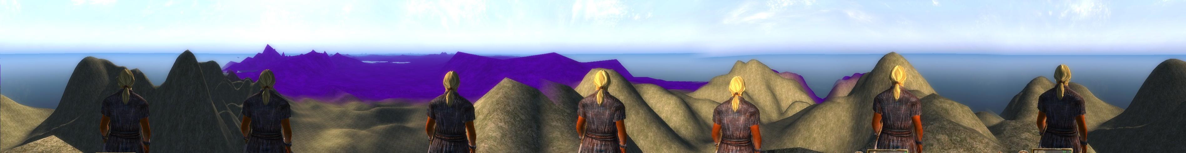
panorama of test HMap - Spoiler:
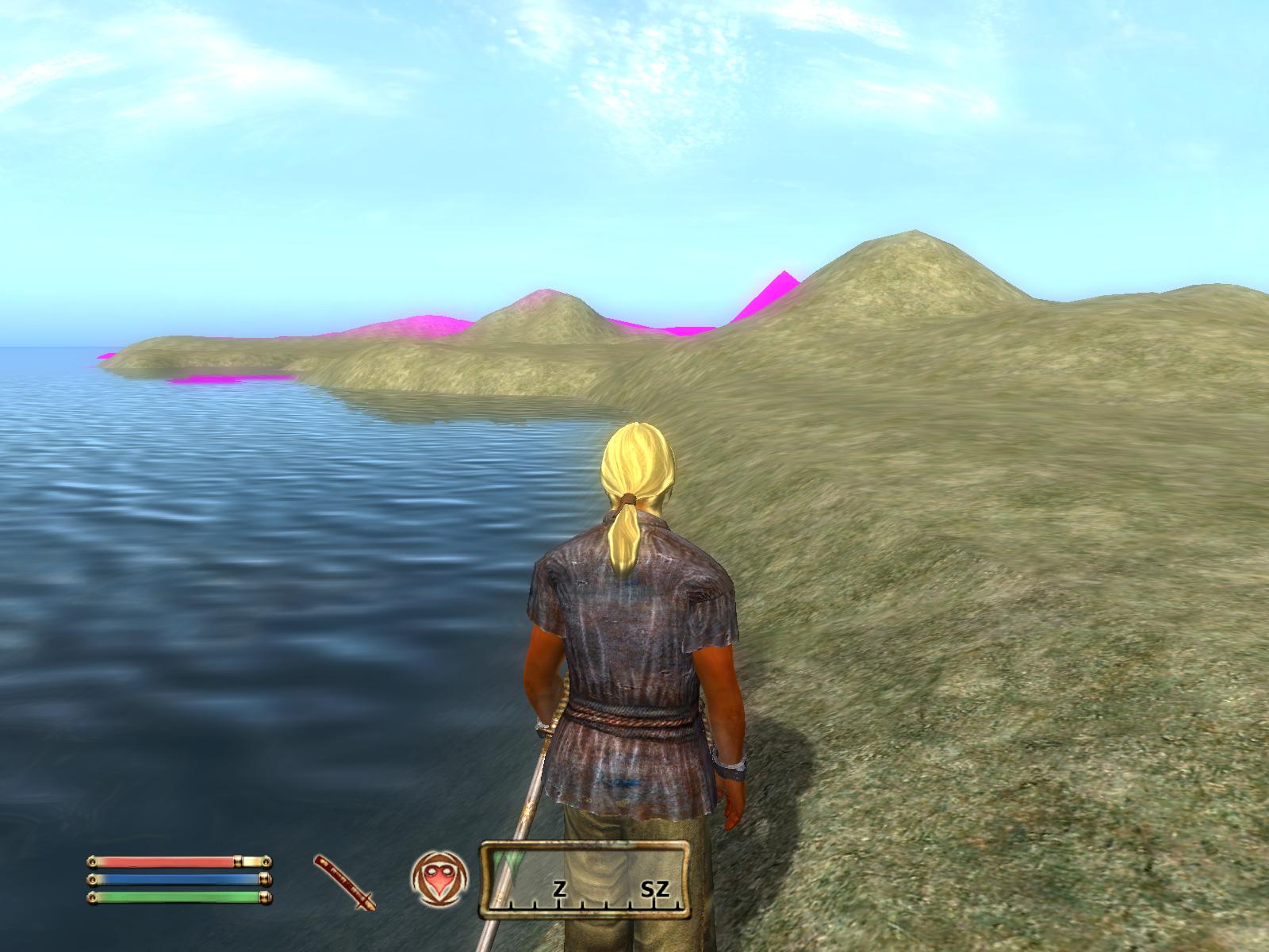
shoreline - Spoiler:
bay - Spoiler:
I know some hills are too steep I will lower them Don't worry about pink/purple land in the distance it can be simply fixed | |
|
| | |
Jaachym
Lead Researcher
Posts : 68
Join date : 2010-02-10
| | Subject: Re: Heightamp preview thread Mon Mar 08, 2010 12:11 pm | |
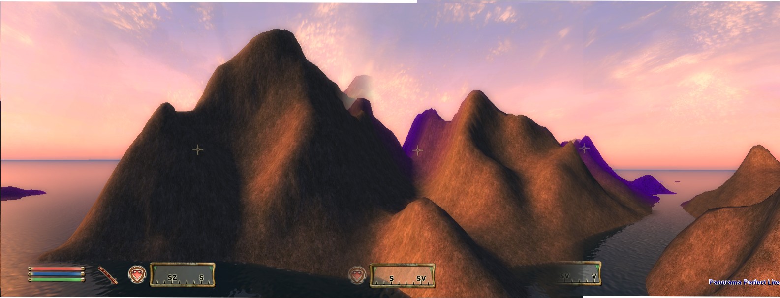
| Hills looks better now - Spoiler:
Also here is test .esp for this part of scotland - Spoiler:
hmtest4.espto get into scotland open console and type "cow aehmtest 4,22" or some other numbers between 0 and 31 (4,22 is ben nevis) | |
|
| | |
Raradir
Admin

Posts : 235
Join date : 2010-02-09
Age : 33
Location : United Kingdom
| | Subject: Re: Heightamp preview thread Mon Mar 08, 2010 4:08 pm | |
| Ok just tested it and I must say a very very very well done, but (and you probably knew the "But" was coming) it is going to have to be alot bigger and I mean alot, the height map looked like it worked well but the mountains need to be alot bigger and as I said above "and I mean alot bigger" as Ben Nevis is basically a hill lol. Anyway a really good start, I hope you don't take this bit of criticism in a bad way but in a way that you can build on it, as it needs to feel realistic like your actually stood in the Scottish Highlands:)
Thanx
Raradir | |
|
| | |
Jaachym
Lead Researcher
Posts : 68
Join date : 2010-02-10
| | Subject: Re: Heightamp preview thread Tue Mar 09, 2010 12:38 am | |
| I thought so but here is the problem
if I would just made it higher it would make unrealisticly steep hills
if I would made map larger say 2 times map would have 4 times larger area ( cca 128 quads)
for all i know maximum map limit is cca 100 quads
and last final question did you ever heard of Oblivion/morrovind mod with such a huge map which has been finished?
I strongly sugest to sacrifice hilliness of hills for the whole mod | |
|
| | |
The hunter
Head Writer


Posts : 57
Join date : 2010-02-12
Location : England
| | Subject: Re: Heightamp preview thread Tue Mar 09, 2010 2:01 am | |
| Im going to have a preview tonight, i have got to be in school in a min so carnt check now... | |
|
| | |
Raradir
Admin
Posts : 235
Join date : 2010-02-09
Age : 33
Location : United Kingdom
| | Subject: Re: Heightamp preview thread Tue Mar 09, 2010 4:06 am | |
| Yea suppose your right, maybe we can sacrifice the size of the mountains and hills to make the land abit more bigger? anyway they will look akot more higher once they have texture and everything on them | |
|
| | |
Jaachym
Lead Researcher
Posts : 68
Join date : 2010-02-10
| | Subject: Re: Heightamp preview thread Tue Mar 09, 2010 4:42 am | |
| yea we can allways add some rocks and stuff... | |
|
| | |
Halperin

Posts : 54
Join date : 2010-03-03
Age : 30
Location : United States
| | Subject: Re: Heightamp preview thread Tue Mar 09, 2010 5:00 am | |
| Well, you could always just edit the heightmap by hand to increase the mountain size. | |
|
| | |
Jaachym
Lead Researcher
Posts : 68
Join date : 2010-02-10
| | Subject: Re: Heightamp preview thread Fri Mar 12, 2010 2:27 am | |
| wash bay - Spoiler:
new sea shore - Spoiler:
| |
|
| | |
Raradir
Admin
Posts : 235
Join date : 2010-02-09
Age : 33
Location : United Kingdom
| | Subject: Re: Heightamp preview thread Fri Mar 12, 2010 4:07 am | |
| Hey the Wash looks really good, except over in the distance its seems to be partially under water lol, but I'm sure that can be fixed. Looking good once we get some landscapers in to change textures add rocks and trees and get some towns and farms etc its gonna look great, looking forwar to more previews:) | |
|
| | |
Jaachym
Lead Researcher
Posts : 68
Join date : 2010-02-10
| | Subject: Re: Heightamp preview thread Sat Mar 13, 2010 7:28 am | |
| Ok , hills will be definitely higher but their base cannot be larger because then wast lowland plains would be even more huge. it is matter of proportions. So when i will make hills higher they wont be bigger they just will be steeper.
So here comes question: what do you think is highest acceptable height? I think 150 maybe 170 % of what is in scotland preview .esp
Feedback apriciated
Thanks
Jaachym | |
|
| | |
Jaachym
Lead Researcher
Posts : 68
Join date : 2010-02-10
| | Subject: bad news everyone Mon Mar 15, 2010 11:24 am | |
| I hava run into problem finding tool that allows me to export 16 bit grayscale from Geotiff or arcascii i have allready exported it in 8 bit grayscale. that means that east anglia looks flat like desk becouse 8 bit grayscale ofers only really small range of height values (256) height difference is like 2 metres so if you guys wont help me find a tol that exports 16 bit grayscale we might resort to adding some noise to the map and simulate erosion to make hight map look less dull and boring. It really sucks becouse I want height map to be precise model of britain. anyway, it does not change much but if some one would find this tool it would be great and second I have to post it here becouse I am frustrated that I have wasted like 8 hours triing to find what perhaps even doesnot exist  | |
|
| | |
Raradir
Admin
Posts : 235
Join date : 2010-02-09
Age : 33
Location : United Kingdom
| | Subject: Re: Heightamp preview thread Mon Mar 15, 2010 12:01 pm | |
| - Jaachym wrote:
- I hava run into problem finding tool that allows me to export 16 bit grayscale from Geotiff or arcascii
i have allready exported it in 8 bit grayscale. that means that east anglia looks flat like desk becouse 8 bit grayscale ofers only really small range of height values (256) height difference is like 2 metres so if you guys wont help me find a tol that exports 16 bit grayscale we might resort to adding some noise to the map and simulate erosion to make hight map look less dull and boring. It really sucks becouse I want height map to be precise model of britain.
anyway, it does not change much but if some one would find this tool it would be great
and second I have to post it here becouse I am frustrated that I have wasted like 8 hours triing to find what perhaps even doesnot exist Hmmm, Have you tried posting on the Oblivion Forums or TESNexus forums to see if anyone knows or if Geotiff or arcascii have forums? | |
|
| | |
Jaachym
Lead Researcher
Posts : 68
Join date : 2010-02-10
| | Subject: Re: Heightamp preview thread Mon Mar 15, 2010 12:45 pm | |
| I am pretty sure that posting on Oblivion Forums or TESNexus forums wouldnt help because nobody ever made such a big hmap which is also representation of real earth elevation data.
Geotiff or arcascii fileformats almost exclusively used by cartographs, meteorologists... and they have no need to export elevation levels into .bmp .png or other formats so i dont see here much hope
it is not really such a big deal but hmap might look a little better if we pulled that of. | |
|
| | |
Raradir
Admin
Posts : 235
Join date : 2010-02-09
Age : 33
Location : United Kingdom
| | Subject: Re: Heightamp preview thread Mon Mar 15, 2010 1:08 pm | |
| - Jaachym wrote:
- I am pretty sure that posting on Oblivion Forums or TESNexus forums wouldnt help because nobody ever made such a big hmap which is also representation of real earth elevation data.
Geotiff or arcascii fileformats almost exclusively used by cartographs, meteorologists... and they have no need to export elevation levels into .bmp .png or other formats so i dont see here much hope
it is not really such a big deal but hmap might look a little better if we pulled that of. Well I don't know what to suggest then. | |
|
| | |
Halperin
Posts : 54
Join date : 2010-03-03
Age : 30
Location : United States
| | Subject: Re: Heightamp preview thread Mon Mar 15, 2010 2:24 pm | |
| I really have no idea what you guys are talking about. I have no idea if this program would be applicable to what you want to do, but would Fractal World Explorer, http://www.nbos.com/products/mapper/fwe.htm, help. Again, I'm not sure if this program would just be completely useless to you. | |
|
| | |
Jaachym
Lead Researcher
Posts : 68
Join date : 2010-02-10
| | Subject: Re: Heightamp preview thread Tue Mar 16, 2010 1:42 am | |
| I have found out that data stored in geotiff (16 bit integrer) have permanently asigned 8 bits to elevathion of sea bottom so no further search is needed | |
|
| | |
Jaachym
Lead Researcher
Posts : 68
Join date : 2010-02-10
| | Subject: First Heightmap relase Fri Mar 19, 2010 1:26 pm | |
| please note that this relase is not intended to landscaping
The map will be redone from a scratch at least 2 more timesI spent six hours or so working on first De-Throned HeightMap relase so here is download link DeThroned_height_map_0.0.1.zipthe map contains whole England, Wales, Scotland, Isle of Man some other isles and part of ireland and france It does not contain any LOD (becouse I have really slow internet conection, so every MB counts) so if you want some you have to generate it yourfelf. to do so follow these steps: - open construction set and load up oblivion.esm, De-Throned_Height_map.0.0.1.esm and De-Throned_Height_map.0.0.1patch.esp
- click world, heightmap editing
- select England
- click view regenerate overview (make sure overview is checked)
- click file generate LOD full
- click in overview window to change wiew then click dont save texture
- click file generate LOD full
you have to generate LOD for each 4 quads displayed in main windowIt should generate LOD meshes for whole world space Known Flaws:- Sealevel is too low (it gets messed up every time I change some parametres) - Some cells are not saved correctly due to overflows or underflows (0,0 for example) - There are several "Rips" in map located on every 5 longitude and latitude degrees (so one passes through greenwich) - hills in wales are as high as scotland highlands (I dint noticed it until yesterday. some progress removing it has been done already) here is reference map: - Spoiler:
to get to isle of man open console and type "cow england -30,35" where -30is x coordinate and 35 is y coordiante to get to other places use reference map Sugestion: use "player.SetActorValue speed 200" and "player.SetActorValue acrobatics 200" console comands I find them very usefull when walking around I have spend working on this map over 50 hours so please test it out for like 2 or 3 hours. would you?Please feel free to criticize Thoughts and Ideas apriciated Jaachym
Last edited by Jaachym on Sat Mar 20, 2010 9:50 am; edited 3 times in total | |
|
| | |
Halperin
Posts : 54
Join date : 2010-03-03
Age : 30
Location : United States
| | Subject: Re: Heightamp preview thread Fri Mar 19, 2010 4:06 pm | |
| The heightmap looks very good. I have two problems with it though. One is that some of the mountains hills are very steep. Considering that some hills are around 50 feet high but I can't climb them, this could be a problem. The mountains too are very steep and impossible to clime up. Also, I noticed that the peaks of some mountains are very pointy. While this may be realistic, there's really nothing to do on a two square foot mountain peak.
Edit: A major problem. Around -78, 150 (I'm not sure what this island is called) there are some major height problems. There are massive spikes and the height must have just gone crazy.
Also, typing in the console player.setav athletics 250 makes you run even faster.
Also, here are some references:
The worldspace is "England," so you would cow england (coordinates) to get somewhere. I wouldn't recommend 0,0 because of the tears jaachym mention.
Some landmarks are:
London is around 61, -47 ish.
Isle of Man is -24, 39. | |
|
| | |
Raradir
Admin
Posts : 235
Join date : 2010-02-09
Age : 33
Location : United Kingdom
| | Subject: Re: Heightamp preview thread Sat Mar 20, 2010 6:06 am | |
| Great Work, I'm going to go test it now, the problems you and Halperin mentioned, are they fixable? | |
|
| | |
Jaachym
Lead Researcher
Posts : 68
Join date : 2010-02-10
| | Subject: Re: Heightamp preview thread Sat Mar 20, 2010 8:04 am | |
| Please note that this relase is not intended to landscaping
The map will be redone from a scratch at least 2 more times
here is patch that fixes "spikes" in -3_4 quad: DeThroned_height_map_0.0.1patch.zipI have accidently skipped one step when i was creating this quad Also I have used Gausian blur functon to make this quad softer and less "edgy" and made hills less steep in other quads please let me know if you like it more with of without blur (or something in between) In next height map relase I plan to get rid of all overflows, underflows, Rips in map and balance hill steepness/highness and in Third relase I plan apply erosion simulation to answer Raradir's question: yes all faults are fixable atrough those rips can be nasty ones (in fact I didnt want to put to much effort into first relase since a lot of things will change and I ll have to start over to do it from a scratch) if you want to what is rip then cow to 0,0 and go west you will notice clearly visible line
Last edited by Jaachym on Sat Mar 20, 2010 8:31 am; edited 2 times in total | |
|
| | |
Raradir
Admin
Posts : 235
Join date : 2010-02-09
Age : 33
Location : United Kingdom
| | Subject: Re: Heightamp preview thread Sat Mar 20, 2010 8:18 am | |
| I'll have to download that patch later, as I'm painstakingly running around the whole coast of England lol to check everythings alright, I've took some screenshots of places that look Kool and places that need improvement, theres not many of the later as all I've seen so far is two rips in the map, the rest is easily done by a landscaper, so far I have gone from the coast near London and now I'm up near Scotland and Island and so far thats took me like nearly two hours lol, as I said I'll post the screenshots once I'm complete, the other thing, France is really really close to England I think in one place its actually attached to England. But so far awesomely Superb work:) | |
|
| | |
Jaachym
Lead Researcher
Posts : 68
Join date : 2010-02-10
| | Subject: Re: Heightamp preview thread Sat Mar 20, 2010 8:34 am | |
| Raradir you have to be mistaken everything has the exact same proportions as shows reference map feel free to post screens here  | |
|
| | |
Raradir
Admin
Posts : 235
Join date : 2010-02-09
Age : 33
Location : United Kingdom
| | Subject: Re: Heightamp preview thread Sat Mar 20, 2010 8:41 am | |
| so England is not attached to France then? its abit confusing trying to figure out where you are lol | |
|
| | |
The hunter
Head Writer
Posts : 57
Join date : 2010-02-12
Location : England
| | Subject: Re: Heightamp preview thread Sat Mar 20, 2010 8:59 am | |
| Okay had a little nose at the heightmap  First note- i love the fact we are getting closeish to having something too work with which is a great feeling. I had several things which i thought may be a problem, one was overalll size but i went for a run and when it took me over 20mins and i wasnt even back where i started i realised its fine I took a few screenshots but they where of a problem already mentioned, the raptures. Okay you know the beaches, well are they each going to have to be smoothed down "by hand"? because the drop between them and the ocean is not realistic. There were a few pot holes around which i noticed. I think the hills need smoothing out but heightwise they werent too bad. Also the issue with land further away looking like sea is a problem too be countered later right? There were several islands in the ocean which i noticed and should be more accessable or summit. Whats LOD?  Have an ice cream Have an ice cream - which also happens too be my first venture into Maya | |
|
| | |
Sponsored content
| | Subject: Re: Heightamp preview thread | |
| |
|
| | |
| | Heightamp preview thread | |
|